
The Science Behind Our Star Maps
Are The Night Sky star maps accurate?
From time to time a customer creates a star map and for one reason or another, doubts the accuracy of the print. We first need to be clear that our star maps have never been and will never be a "generic" print: We individually and precisely render each star map for the chosen time and place and guarantee accuracy! We are very proud of our star maps and so we hate to see people concerned that their print might be incorrect, so we will always do our best to reassure you in any way we can.How to verify your star map is accurate:
How can I check my map is accurate myself?
The first thing you can do is to compare with a third party, to see that our maps are accurate. Sky And Telescope, a popular astronomy magazine (with no affiliation to The Night Sky) has an interactive sky chart that you can use to verify your map details: http://www.skyandtelescope.com/interactive-sky-chart/ You can also download free astronomy software such as Stellarium (stellarium.org) to explore the night sky in a more interactive way and to compare against your print.It’s one thing to show that third parties agree that the print is accurate, but that doesn’t answer the question that may have raised concern in the first place: why the prints appear as they do and how could a pair of maps which appear very similar, despite coming from different times or from different locations? Or conversely, how two could star maps look different, despite coming from apparently the same date and location.
These cases are rare but perfectly possible. We will discuss these and other specific cases below, but first we need to describe (the somewhat complicated mechanics of) how the stars move and the factors that influence which stars you see in the Night Sky.
Why do the stars appear to move across the sky?
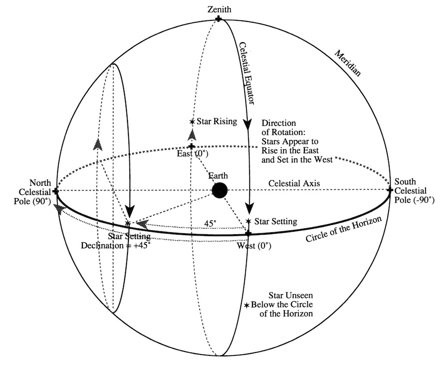
How the stars moveWe say that the stars move, but in reality, the stars don't move relative to one another by any measure that we can see the change visually here on Earth. What's actually happening is that we - here on spaceship earth - are moving beneath them. To try to visualize this you can try to imagine the sun hanging in space and the earth slowing orbiting around it. Surrounding that, you should then imagine a huge globe with the stars painted upon it - a fixed background with the sun in the middle and the earth slowly rolling around it.
We call this imaginary globe of stars the "Celestial Sphere". Hopefully, by now you're now imagining something like this image (via Google Images):
How do the earth's rotation and orbit change what I see?
Of course, we're not running laps around the earth each day! More usually we stay - on a global scale - in more or less the same location, but the earth is spinning beneath us and carrying us along with it.The earth rotates every 24 hours so that at noon you're looking straight up at the sun, toward the center of our imaginary celestial sphere. At midnight, looking straight up means looking directly away from the sun and out into the heavens. As the earth rotates, this "straight up" position away points out at a slightly different set of stars, moment to moment, hour to hour, so that they appear to move across our sky during the night. At night we see one half of the celestial sphere and as the earth turns us to daytime, the brightness of the sun (and in part the sun itself) blocks our view of the stars on the other side of the Celestial Sphere, beyond the sun in the center of our model.
As days and months pass, the earth also moves around the sun so that each night at midnight we look straight up and away from the sun and out at a slightly different piece of sky. In 6 months we move to the opposite side of the sun, looking out at the opposite side of the celestial sphere and after 12 months we have completed an orbit, back to the original position.So you see that the stars change on an annual cycle. This is one of the nice things about the star maps. The stars we see on a date this year are the same as those we see 1 year later, 10 years later or 100 years later (ignoring for the simplicity of this explanation, some slower and more subtle effects that occur over centuries).
How is the sky calculated for my date and place?
So we can now see how time affects the positions of the stars through the earth’s rotation. The second factor that influences the stars we see, is our location on Earth.The star map displays the entire dome of the Night Sky as you see it above you. The edge of the circle represents the horizon and with the center of the circle is the point straight up above you. The stars to your North are in the top half of the map, the South to the bottom, East to the left (you're looking up) and West to the right. The circle displays half the celestial sphere - on any cloudless night with a clear horizon you can look out into half the universe! That’s 180 degrees of sky in all directions.
If you think about the earth as a little globe floating inside the celestial sphere, you know that at any time half of the celestial sphere is above you - the rest is behind the globe you're standing on. If you change location and move to the other side of the globe, you would see the other half. Moving around the globe would move the stars by an equivalent amount - remember the stars aren’t moving - you are!
What star catalogue do you use?
We calculate the position of every star on your map from the Hipparcos catalogue published by the European Space Agency (ESA). It is a high-precision catalogue built from more than three years of observations by the Hipparcos satellite, and the positions for your chosen date, time and place are computed from that data, not traced from a stock image.What does the map show, and what does it not show?
Every map shows the stars visible from your location at your chosen moment, along with the constellation lines and the Moon. It does not show the planets, and constellation names are not printed on the map itself; instead, every order includes the Constellation Legend eBook, which identifies and explains the constellations on your map. As well as prints and jewellery, your star map is also available as a digital download.Why might two maps from different places look almost the same?
How can two star maps from different locations look the same?Sometimes we are asked why a star map from one location looks like another. Because we're looking at half of the celestial sphere, the scale of the map is very large - horizon to horizon, the amount of sky you can see above you is massive, much like if you were to look at half of the globe. Often the issue is simply that the difference is too subtle at the scale of the map. For example, Washington and New York are separated by only 7 degrees of latitude: a minor shift within the 180 degree expanse of the star map!
A more interesting example of this can be found in a shift from New York to San Francisco or Sydney to Perth. In the latter case, the North-South separation is less than 2 degrees, however the cities are separated East/West by almost 4,000 kilometers on opposite ends of the Australian continent! So how for the same date, might their star maps show the same skies?
The answer in this instance, comes with time. By default, we render star maps at 10 PM in the evening, since these are the stars and constellations that people remember seeing and ask us about on the date they wish to remember. And strictly speaking, rendering at midnight would show the stars for the following day!
The time chosen is local time, so if you were to render two star maps for the same date for example in New York and San Francisco, the stars rendered in the New York map would be at 10 PM New York time, and the stars in the San Francisco maps would be for 10 PM San Francisco time, 3 hours later! During this time, the earth has rolled around underneath the stars, so that San Francisco is looking up at the same stars that were above New York earlier.
You can render the stars for the same moment in time by making appropriate adjustments to the time - in this example, setting the New York time to 11 PM and the San Francisco time to 8 PM, for example, which would give you quite different maps (rotated 48 degrees, their difference in longitude). You can select a specific time on the desktop computer/laptop version of our site, by expanding the "Advanced Options" section.
Why does my map look different from one I ordered before?
“How could two star maps look different for the same date” (or “My star map doesn't match the star map I ordered 1 year ago”)It's a great compliment that many of our customers return to buy second and third copies of the prints they have previously purchased. Sometimes, however, they note with alarm that the stars have changed between their earlier print. This is nothing to be alarmed about!
We have moved our default time over the months before settling on 10 PM. Typically, the earlier print is a slightly earlier time and we have found the later time of 10 PM to be a better default because for some Northern and Southern extremes, the sunset occurs very late in the evening during the summer months.
We would like to encourage our customers to pay attention to the time if they are ordering repeat prints and to read these notes carefully to understand that this is a change in time and does not mean that the map is inaccurate. However, if your print arrives with a time you were not expecting then as with any customer concern, we will do whatever we can to to make it right and make sure you are completely satisfied with your print.
How could two star maps months apart look similar?
Since providing the option to select a specific time to render the stars, we've had some interesting cases where customers have expressed concern about star maps months apart looking very similar.In one fascinating case, a mother's two children were born two and half months apart under a virtually identical sky! In all cases that we have addressed thus far, each has been the result of the combination of the date, in the orbit on the earth around the sun, and the time, in the earth's rotation.
If you remember again our imaginary image of the earth sitting inside a huge globe of stars: We know that the earth rotates around the sun every 12 months, so in 6 months at midnight we are looking out at a half of the celestial sphere immediately opposite the site we look out at 6 months later. We also know that the earth rotates every 24 hours, so after 12 hours we're pointing back towards the side we pointed at 6 months ago! So for example we point at the same stars at midday in January would at midnight in July!
Obviously, in this case the sun should be blocking one or the other views and we wouldn't necessarily encourage you generate star maps for the middle of the day (although you might remember that the stars are still there even when you can't see them)! Usually in these cases, the difference is a matter of a few months or between dawn and dusk. At midnight one month to the next, our view of the celestial sphere will have moved 30 degrees. Since each hour the earth rotates 15 degrees, 1 month is equivalent to 2 hours of rotation - put another way, an 6 AM map one month will look virtually identical to a map drawn at 4 AM map a month later.
Frequently Asked Questions
Are The Night Sky's star maps actually accurate?
Yes. Every star map is individually and precisely rendered for the exact date and location a customer chooses; nothing is a generic or templated print. The team takes accuracy concerns seriously: when a customer doubts a print, the goal is always to work through the astronomy with them and show why the sky looked the way it did, rather than dismiss the question. Two maps that look alike, or a pair from the same date that look different, both have a rational explanation rooted in how the earth rotates and orbits, not in printing errors.
How can I check my map's accuracy myself?
Compare it against a third party. Sky & Telescope, an independent astronomy magazine with no affiliation to The Night Sky, publishes a free interactive sky chart at skyandtelescope.com that lets you verify the stars for any date and place. Free desktop software such as Stellarium (stellarium.org) works the same way and is more interactive, letting you explore the night sky and compare it directly against your print. Both are unaffiliated third parties.
Why might two star maps from different locations look almost identical?
Because the map shows half the entire celestial sphere, 180 degrees of sky, small differences in latitude barely register at that scale. Washington and New York, for instance, are only 7 degrees of latitude apart, a minor shift within a 180-degree view. Even a much bigger East-West gap, like Sydney to Perth (nearly 4,000 kilometers apart but under 2 degrees of latitude difference), can render similarly once you account for local time: each map defaults to 10 PM local time, so the earth has simply rotated underneath the stars between the two places.
Why might my new map look different from one I ordered before for the same date?
Most likely a default-time change, not an error. The site has adjusted its default render time over the months before settling on 10 PM, chosen because it works better for far-northern and far-southern locations where sunset happens very late in summer. If an earlier order was rendered at a slightly earlier default time, a repeat print of the same date will show a genuinely different, but still accurate, sky. This is a deliberate default change, never a sign the map is wrong.
How could two star maps taken months apart look almost the same?
It happens because of how rotation and orbit combine. The earth completes an orbit every 12 months and a rotation every 24 hours, so a position 6 months and 12 hours apart points at nearly the same patch of sky. For example, midday in January looks similar to midnight in July. One customer found two children born two and a half months apart under a virtually identical sky for exactly this reason. In practice the effect shows up over gaps of a few months, or between dawn and dusk.
Where can I learn more, and how do I raise a concern?
Recommended ReadingIf you'd like to read some more about the mechanics of how the stars move and learn about how to locate constellations in the Night Sky, then I'd recommend the book called "The Stars", by H. A. Rey.
If you have any concerns about the accuracy of our maps that we do not address here, or wish some point to be clarified, then please do let us know. We'll always do our best to address your concerns and to make sure you are as proud and happy as we are in the quality and accuracy of our star maps. We can also send you a gif file if you want to show you the difference.
Comparing star map companies? See how The Night Sky compares with Under Lucky Stars and our guide to choosing a custom star map company.
Our Promise
QUALITY
We print on museum grade using paper and only use precious metals in our jewellery.
CARE
With 41,947 reviews, we go above and beyond for our customers.
CONSCIENCE
We print on paper from FSC approved forests and all of our silver and gold is recycled.
Sign Up
Sign up for product updates, exciting space stuff and the occasional discount code.
By signing up you agree to our Privacy and security policy